Kilpisjärvi: Hiking the Three-Country Cairn in Summer
At the far northwestern tip of Finland, where Finland, Norway, and Sweden meet at a single stone cairn in an arctic lake, is one of the most extraordinary hikes in Scandinavia. A couple from Lapland shares what the Kilpisjärvi hike is really like — and why the drive there is almost as good as the destination.
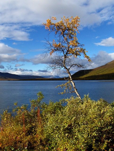
The road to Kilpisjärvi takes you through some of the most dramatic scenery in Finland. We drove it from Rovaniemi in early summer — about four and a half hours northwest along the E8 highway, following the river valley as the landscape shifts from birch forest to open fell, from fell to something that starts to look genuinely alpine. By the time you reach the village itself, sitting at the edge of a wide, still lake with Norwegian mountains rising directly across the water, it feels less like Finland and more like somewhere you were not expecting to end up.
The Kilpisjärvi hike to the Three-Country Cairn is technically a day walk, but it is one of those hikes that stays with you. You cross from Finland into Norway on foot, wade across a shallow lake channel to step onto a stone monument that marks the single point where three countries touch, and then turn around to find one of the finest views in Lapland laid out in front of you. Here is everything you need to know before you go.
The Kilpisjärvi hike to the Three-Country Cairn (Kolmen Valtakunnan Rajapyykki) is a 12 km round trip over open fell and gentle terrain, taking 4–6 hours for most walkers. The cairn sits in the middle of a shallow lake at the point where Finland, Norway, and Sweden meet. The best time is June to September, when the trail is snow-free and the midnight sun makes an evening hike genuinely magical.
- What the Three-Country Cairn actually is
- The Kilpisjärvi hike: route, distance, and what to expect
- Quick-reference: dates, logistics, and key facts
- What to expect from the weather and conditions
- The Three-Country Cairn vs the Saana fell hike
- Mistakes hikers make on the Kilpisjärvi trail
- FAQ: Kilpisjärvi hike
- A final word from Lapland
What the Three-Country Cairn actually is
The landmark at the meeting point of three nations
The Three-Country Cairn — Kolmen Valtakunnan Rajapyykki in Finnish, Treriksroysa in Norwegian, Treriksroset in Swedish — is a granite obelisk standing in the middle of Lake Goldajoki at the precise point where the national borders of Finland, Norway, and Sweden converge. It was first erected in 1897 and rebuilt in its current form in 2005. The cairn is surrounded by water for most of the summer season, which means reaching it involves a short wade or, in high summer, hopping across stepping stones to the monument itself.
The location is one of the most remote and architecturally simple landmarks in Scandinavia, yet the experience of standing on it is oddly moving. You are in three countries simultaneously. Finland is behind you. Norway is to the west. Sweden to the southeast. The lake reflects the sky. Reindeer sometimes graze on the surrounding fell. And if you are there late enough in June or early July, the sun has not set for weeks.
The geography of Kilpisjärvi
The village of Kilpisjärvi sits at 473 metres above sea level, making it Finland’s highest permanently inhabited settlement. It is a tiny place — a few hundred residents, a hotel, a visitor centre, a handful of cabins for rent, and the Saana fell rising steeply behind the village to 1029 metres. The combination of the high elevation, the open treeless landscape, and the proximity to Norwegian and Swedish fjord country gives Kilpisjärvi a completely different character from the rest of Finnish Lapland. It is the most alpine-feeling place in Finland by a significant margin.
- Distance from Rovaniemi: approximately 480 km, 4.5–5 hours by car
- Distance from Tromsø (Norway): approximately 200 km, 2.5 hours by car
- Village altitude: 473 m above sea level
- Saana fell summit: 1029 m (accessible on a separate trail from the village)
The Kilpisjärvi hike: route, distance, and what to expect
The trail from the village to the cairn
The standard route to the Three-Country Cairn starts from the Kilpisjärvi visitor centre car park and follows a well-marked trail across open fell and boggy terrain. The path is mostly flat or gently rolling — this is not a mountain climb in the alpine sense, but it is 12 km round trip over uneven ground with very little shelter, which is something to plan for carefully.
The trail crosses into Norway well before the cairn itself. There is no border control of any kind — you simply walk over an invisible line on an open fell, marked by a small sign. This is one of those moments that feels genuinely liberating. The Schengen Area at its best.
The final section of the hike drops down to the lake shore where the cairn stands. In early summer (June), the water level is higher after snowmelt and you may need to wade ankle-to-knee-deep to reach the monument. By July, stepping stones often emerge. We went in late June and waded. Cold, yes. Worth it, absolutely.
Practical route details
- Trailhead: Kilpisjärvi Visitor Centre (Retkeilykeskus), there is a large car park
- Distance: approximately 12 km return (6 km each way)
- Elevation gain: minimal — the route is mostly flat fell walking with some gentle climbs
- Walking time: 4–6 hours return at a relaxed pace
- Terrain: open fell, boggy sections, some rocky ground near the cairn, possible wading
- Waymarking: yellow-topped posts, well-signed throughout
- Dogs allowed: yes, on a lead in some sections (reindeer are present)
Quick-reference: dates, logistics, and key facts
The trail is accessible from approximately mid-June to mid-September, when the ground is reliably snow-free. July is the warmest month and the driest. June offers the full midnight sun (the sun does not set at Kilpisjärvi altitude from roughly late May through mid-July).
There is no regular public transport to Kilpisjärvi from Rovaniemi in summer. You need a rental car, your own vehicle, or you can arrange a private transfer from Rovaniemi or Tromsø. The drive from Rovaniemi takes approximately 4.5 hours along the E8. From Tromsø it is about 2.5 hours.
The main accommodation option in the village is Kilpisjärvi Retkeilykeskus (the visitor centre hotel), which also has camping and cabin rentals. Book well in advance for summer. There are also a few private cabin rentals in the area on sites like Booking.com or Lomarengas.
Waterproof boots or sandals for potential wading, gaiters for boggy sections, a full rain layer (weather can change in minutes at this altitude), sun protection (the UV is stronger than it looks under the midnight sun), snacks and water for the full 6 hours, a paper or offline map as signal can drop.
The trail to the Three-Country Cairn is free to walk. There is no entrance fee for the hike or the cairn itself. Parking at the visitor centre is free.
In summer, a boat service operates from the visitor centre jetty to a point much closer to the cairn, cutting the hike to roughly 3 km return. This is a great option for families with young children or anyone with limited mobility. Check the visitor centre for the current season schedule and pricing.
Related reading If you are combining this with a broader Lapland summer trip, see our guide Rovaniemi in Summer: 15 Things to Do Beyond Santa Claus Village for ideas on how to build the full itinerary from our home base.
What to expect from the weather and conditions
Kilpisjärvi weather is notoriously variable. We have spoken to people who did the hike in brilliant sunshine and returned to the car in a full rainstorm, all in the same afternoon. The high fell environment means that even in July, the temperature can drop sharply with cloud cover. Do not treat this as a summer stroll in trainers.
Month-by-month conditions
- June: the peak midnight sun period. Snow may still linger in sheltered spots early in the month. Trail can be wet from snowmelt. Extraordinary light. Cool to cold temperatures (5–15°C). We think this is the best month for the hike if you can tolerate variable weather.
- July: warmest month, driest conditions, most reliable. Average temperatures of 12–18°C. The midnight sun is ending but the days are still extremely long. Busiest period — the boat service is fully operational and the trail sees the most foot traffic.
- August: still excellent. Cooler than July. Berries ripen on the fell. The first hints of autumn colour appear in late August and the northern lights begin to be visible again on clear nights. A beautiful and quieter time to hike.
- September: autumn colours peak in early September in Kilpisjärvi. The ruska (autumn foliage) here is spectacular because of the open fell landscape. The trail can become snowy later in the month. Pack winter layers alongside your rain gear.
The Three-Country Cairn vs the Saana fell hike
Kilpisjärvi offers two main hike options and travellers often wonder which to prioritise if they have limited time. Here is our honest comparison.
- Three-Country Cairn hike: 12 km return, mostly flat fell, 4–6 hours, ends at a landmark in a lake. The experience is about the crossing, the openness, and the surreal landmark. Lower physical demand, higher sense of adventure.
- Saana fell hike: approximately 8 km return, significant elevation gain (roughly 550 m from the village), 3–4 hours, summit at 1029 m with a full 360-degree view across three countries. More physically demanding, but shorter overall and the views from the summit are arguably more dramatic.
- Both in one trip: possible if you are fit, you have a full day, and the weather cooperates. We would not recommend doing both as back-to-back long days without proper rest and the right footwear. Pick one and do it properly.
- Which one first? We recommend the Three-Country Cairn hike for most visitors. The cairn is unique — there is only one place in Scandinavia where you can stand in three countries at once — and the fell crossing is an experience that Saana cannot replicate even with better views. Do Saana on a second day or for your next trip.
- Families with children: the boat option makes the Three-Country Cairn far more accessible for young kids. Saana involves a real scramble in sections and is not suitable for small children.
Get our best travel tips in your inbox
Monthly stories from Rovaniemi — Arctic tips, packing lists, and the places we keep coming back to.
A final word from Lapland
We live in Rovaniemi, which means the drive to Kilpisjärvi is possible as a long weekend trip for us. We have done it twice now — once in late June for the full midnight sun, once in August when the fell was beginning to turn russet at the edges — and we would do it again without hesitation. It is one of those places that does something to your sense of scale.
The Three-Country Cairn itself is not a grand monument. It is a modest granite column standing in a shallow lake on an open fell. But the journey to reach it — the long drive through Lapland, the crossing into Norway on foot, the wading through cold water, the moment you step onto the stone and realise that three of the most beautiful countries in the world meet right here — is genuinely unlike anything else in Scandinavia.
If you are already going to be in Lapland in summer and you have a car, Kilpisjärvi should be on your list. It is at the edge of the world, and the edge of the world turns out to be rather lovely.
Questions about the route, timing, or combining it with other Lapland stops? Drop us a message. We answer.
— Joona & Alla, Rovaniemi
Joona & Alla
We are a Finnish-Ukrainian couple based in Rovaniemi, Finnish Lapland, who have explored 25 countries together. Joona works in tourism marketing; Alla focuses on content and AI. We built Hungry Travel Family to share honest, locally-grounded travel knowledge from our home in the Arctic.
About us →