Faroe Islands Road Trip: What Surprised Us
We drove every main island of the Faroe Islands across five days — no tour, no itinerary template, just a rented car and two people from Rovaniemi who thought they knew dramatic landscapes. We were wrong. Here is what actually caught us off guard.
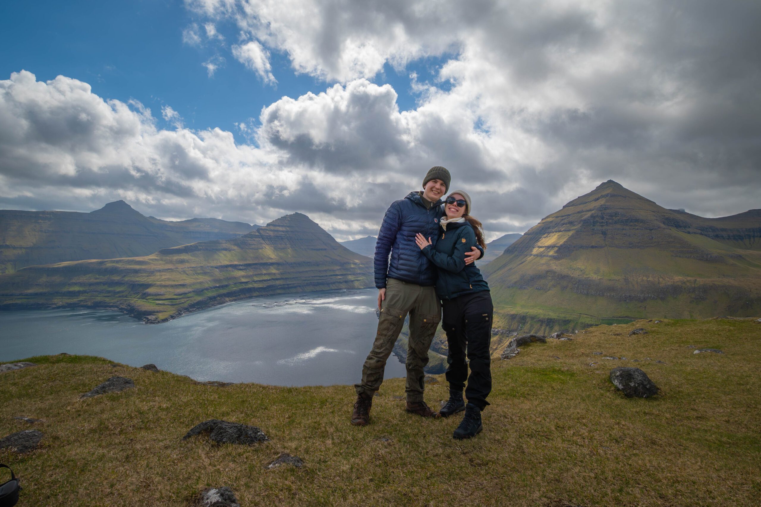
We live in Rovaniemi. We know dramatic. Arctic light in January, reindeer crossing empty roads, frozen rivers that go silent in a way that feels prehistoric — we are not easy to impress with landscapes. The Faroe Islands impressed us.
This is not a highlights reel. It is the list of things that caught us genuinely off guard on our self-drive road trip across the main islands — the things no article we read beforehand actually prepared us for.
A Faroe Islands road trip surprises most visitors in the same ways: the scale of the cliffs is bigger than photos suggest, the weather changes faster than any forecast can track, the tunnels under the ocean are genuinely surreal, and the islands are far easier to drive independently than their remote reputation implies. Go in summer, rent a small car, and give yourself at least five days.
- The scale of the landscape caught us off guard
- The weather is a travel companion, not a problem
- The submarine tunnels — what it is actually like to drive them
- How easy the self-drive logistics turned out to be
- What we got wrong before arriving
- Mistakes we made on the road
- Frequently asked questions
- A final word from Rovaniemi
The scale of the landscape caught us off guard
Every photo of the Faroe Islands has the same problem: it flattens the cliffs. You see a green hill dropping into blue water and think, nice. Then you stand at the edge of Enniberg — the highest vertical sea cliff in the world at 754 metres — and your body does something that photographs cannot replicate. It gets very still.
We had seen cliffs in Norway. We had driven the Atlantic Road and stood at Preikestolen. The Faroe Islands felt different, and after five days we think we understand why: the islands are small enough that you are never far from an edge, and there are almost no guardrails. The landscape is not displayed to you from a viewing platform. You are simply in it.
The moments that actually stopped us in our tracks
- Saksun: a grass-roofed village at the end of a single-track road, with a tidal lagoon that floods and drains twice daily. We arrived at low tide and walked across the sand to the open Atlantic. Nobody else was there.
- Gásadalur waterfall: water falls directly from a cliff into the ocean below. The village behind it has 18 residents. The scale ratio of waterfall to village is completely wrong in the best way.
- Vestmanna bird cliffs: we took the boat. The boat goes under overhangs. The birds are in the thousands. It smells of salt and feathers and the engine echoes off rock that has been there since before people.
- The road from Eiði to Gjógv: narrow, unmarked, rising steeply with the Atlantic on both sides of the peninsula. No other cars for forty minutes.
The weather is a travel companion, not a problem
We read so many warnings about Faroe Islands weather before we went that we almost packed raincoats as our primary clothing. The weather is genuinely extreme — wind, rain, fog, and bright sunshine can all happen in the same hour. But after a few days, something shifted in how we experienced it.
We stopped checking the forecast and started watching the sky. When a cloud bank rolls in from the west, you have roughly twenty minutes before it reaches you. That is enough time to decide: push on and get wet, or pull over and wait. The rhythm of the islands is built around this negotiation, and once we accepted it, the weather stopped feeling like an obstacle and started feeling like the trip itself.
What the weather actually meant in practice
- Day 1: fog so thick we could not see the waterfall at Múlafossur from 50 metres away. We waited 35 minutes. The fog lifted for exactly 12 minutes. We got the photo.
- Day 2: clear all day. The kind of light you dream about — low angle, gold, with shadows cutting across the green hillsides like something from a landscape painting.
- Day 3: horizontal rain from 9 am to 3 pm, then the clearest evening of the trip.
- Practical rule we learned: if the forecast says 60% rain, that is Faroese for “normal Tuesday.” Go anyway.
The submarine tunnels — what it is actually like to drive them
The Faroe Islands have tunnels that go under the sea. Not over the sea, not beside the sea — under it, connecting islands that were previously only reachable by ferry. We knew this before we arrived. We did not know what it would feel like.
The Vágatunnilin connects Vágar island — where the airport is — to the main island of Streymoy. It is 4.9 km long, drops steeply to its lowest point under the Vestfjord, and then rises again on the other side. The walls are raw basalt. The road is lit with amber light that makes everything feel slightly underwater. There is a roundabout in the tunnel — an actual roundabout, underground, under the sea — where you turn off toward Sandoy.
The tunnel details worth knowing before you drive
- Eysturoyartunnilin: the newest tunnel, 11 km, connects Eysturoy to Streymoy. Has two roundabouts underground. Toll: approximately 100 DKK per crossing for a standard car.
- Vágatunnilin: connects Vágar (airport island) to Streymoy. Single lane in sections with passing places. Drive slowly and use the passing bays.
- Norðoyatunnilin: connects the northern islands to the main island group. Longest at 6.3 km. Worth doing even if you do not have specific plans on the northern islands.
- Toll payment: the Faroe Islands use a cashless toll system called Umferðarstofa. Register your rental car’s plate online at faroeislands.fo or at the tunnel kiosks before driving through — your rental company should explain this, but not all of them do.
- Claustrophobia check: if narrow tunnels bother you, the Vágatunnilin requires a calm head. It is not dangerous, but it is confined, dimly lit, and the oncoming headlights appear suddenly on bends.
Stories from the edge of Europe, direct to your inbox
We write about the places that still feel remote. No fluff, no sponsored filler — just honest travel from Joona & Alla.
How easy the self-drive logistics turned out to be
The Faroe Islands have a reputation for being difficult to navigate independently. The roads are narrow, the weather unpredictable, the islands spread across open Atlantic. We expected logistical stress. We did not find it.
The island group is compact. Tórshavn, the capital, is genuinely small — you can walk from one end of the old town to the other in ten minutes. The roads, even the single-track ones, are well-maintained and well-signed. Almost every local we asked for directions spoke excellent English and gave us specific, useful answers.
The practical logistics that worked well
- Car rental: we used Faroe Car Rental at Vágar airport. Small hatchback, unlimited mileage, cost roughly €65 per day in May. The car needs to be small — some roads on the northern islands genuinely do not fit a large SUV.
- Navigation: Google Maps works well on the main islands. For the smaller northern islands, download an offline map before you go — signal disappears in the tunnels and on exposed peninsulas.
- Accommodation: book at least the first and last nights in advance. Mid-trip flexibility is fine — there are small guesthouses on most islands and the tourist office in Tórshavn can call ahead.
- Fuel: the Faroe Islands have petrol stations on Streymoy, Eysturoy, Vágar, and Suðuroy. Fill up whenever you see one on the smaller islands. We never ran below a quarter tank on the main islands; on Suðuroy we filled at every opportunity.
- Ferries: the Landsverk ferry system connects islands not linked by tunnel. Timetables are regular and reliable. The Gamlarætt–Skopun ferry to Sandoy runs roughly every hour in summer. No booking required for foot passengers; car bookings are recommended in high season.
What we got wrong before arriving
We had spent time reading about the Faroe Islands before we went, which meant we arrived with a specific picture in our heads. Most of it was wrong, or at least incomplete.
- We expected it to be cold. In May it was 10–14°C most days — cool but not cold. Layering solved everything. We never needed the heaviest coats we packed.
- We expected it to be empty. It is not empty. Tórshavn has restaurants that fill up and places worth booking. The viewpoint at Lake Sørvágsvatn (the famous “lake above the sea” optical illusion) had perhaps fifty people on a Tuesday morning.
- We expected the food to be basic. It is not. RÆST — the Faroese technique of wind-drying and fermenting meat and fish — is genuinely interesting, and the restaurant Koks (now relocated to Greenland, but its spiritual successors remain) set a template for ingredient-focused cooking that several Tórshavn restaurants are continuing.
- We expected the islands to feel cut off from the world. They do not. The infrastructure — tunnels, roads, broadband, card payments everywhere — is modern Scandinavian standard. What they feel like is chosen isolation. The Faroese have good roads and fast internet, and they also still dry mutton legs in wooden sheds called hjallur. Both things are true.
- We expected to need a tour. We did not. The only activity where a guide added real value was the Vestmanna bird cliffs boat trip, where local knowledge about when to approach specific caves made a genuine difference.
The Faroese attitude to visitors — the surprise we saved for last
We travel a lot. We have been to 21 countries from our base in Rovaniemi, and we have developed a reasonable sense of when a place is tired of tourists. The Faroe Islands are not tired of tourists. But they are also not performing for them.
The locals in Gásadalur did not wave at us as we walked past their houses to the waterfall. They also did not glare. They were living their lives, and the waterfall was there, and we were welcome to look at it, and all three facts coexisted without tension. We found that more refreshing than we expected.
- What “sustainable tourism” looks like in practice here: limited parking at sensitive sites (you park and walk, sometimes 45 minutes), visitor fees at Saksun and Lake Sørvágsvatn, explicit signage about not crossing marked boundaries. The rules are clear and most people follow them.
- The language: Faroese is its own language, descended from Old Norse, spoken by 50,000 people. Everyone also speaks Danish and English. We learned three Faroese words (takk = thank you, góðan dag = good day, hvussu eitur tú = what is your name). The reaction to even this small attempt was warm every time.
- The pace: slower than Scandinavia, faster than rural Finland. Cafés do not rush you. Restaurants expect you to be there for two hours. We ate our slowest, most pleasant dinners of the year in Tórshavn.
Mistakes we made on the road
- We underestimated driving time. The roads are beautiful and the speed limit is 50–80 km/h across most of the islands. A 30 km journey that looks easy on a map can take an hour because of single-track sections, sheep on the road, and the fact that you will stop repeatedly to stare at things.
- We skipped Suðuroy on the first trip. The southernmost island requires a 2-hour ferry from Tórshavn and is the least visited main island. Two Faroese people told us independently it was their favourite. We did not go. We regret it.
- We brought the wrong shoes. Trail runners were fine for marked paths. For the unmarked ones — grass-covered basalt, sometimes wet — proper hiking boots with ankle support would have made a difference.
- We booked a guesthouse that did not include breakfast. In a village with no café, this meant driving 25 km before we had eaten anything. Book accommodation that includes breakfast, or bring food from Tórshavn.
- We tried to drive too much in one day. Five islands in a day felt efficient on the map and exhausting in practice. Four hours of dramatic landscape requires processing time. Build in afternoons that have no plan.
- We did not register the rental car for tolls before entering the first tunnel. The fine is 600 DKK. Register online before you drive anywhere near a tunnel.
Frequently asked questions
Is the Faroe Islands road trip suitable for first-time self-drive travellers?
Yes, with one caveat: the single-track roads require confidence and patience. If you have driven in Ireland, rural Scotland, or Norway, you will be fine. If you have never encountered a single-lane road with passing bays, spend the first day on the main island of Streymoy, which has wider roads, before moving to the smaller islands.
How many days do you need to road trip the Faroe Islands?
Five days is the practical minimum for the main islands. Seven days allows for weather delays, a ferry day to Suðuroy, and the slower pace the islands reward. We spent five days and left with a list of things we had not seen. A week would have felt complete.
What is the best time of year to road trip the Faroe Islands?
May to August for longest daylight and best road access. June for puffin season on Mykines island. May and September have fewer visitors than July and August. We went in May and found it excellent — mild weather, manageable crowds at the main viewpoints, and long evenings that made driving feel unhurried.
Do you need to book ferries in advance?
For foot passengers, no — turn up and board. For cars in peak summer, yes — the Gamlarætt–Skopun ferry to Sandoy and the Tórshavn–Suðuroy route can fill up. Book at ssl.faroeislands.fo at least a day ahead. The Norðoyatunnilin tunnel has replaced the northern ferry routes, so you do not need a ferry to reach the northern islands anymore.
Is the Faroe Islands expensive?
Yes — roughly on a par with Iceland or Norway. Budget around €120–150 per person per day for accommodation, food, rental car split between two, and activities. The main costs we did not anticipate were the tunnel tolls (cumulative across five days, they added €60–80 to our budget) and the Vestmanna boat trip (around €50 per person but genuinely worth it).
Can you drive to the Faroe Islands from mainland Europe?
No. The Faroe Islands are in the middle of the North Atlantic. You arrive by plane (mainly via Vágar airport, with direct connections from Copenhagen, London, and Reykjavik) or by the Smyril Line ferry from Denmark (Hirtshals) via Iceland, which runs weekly in summer and is a trip in itself. Flying is faster; the ferry is an experience.
A final word from Rovaniemi — on places that still feel like themselves
We talk a lot about “hungry for travel” as the thing that drives us — the feeling of arriving somewhere and not quite knowing what to expect, and then the landscape or the food or the people exceeding whatever picture you had built. The Faroe Islands did that.
Part of it is the physical reality of the place: cliffs that are genuinely among the most dramatic in the world, weather that keeps you honest, a road network that is modern enough to be safe and narrow enough to stay interesting. But a larger part of it is the Faroese choice to remain legible as themselves. The infrastructure is Scandinavian. The culture is something older, specific, not easily exported. Both things sit together without friction.
We came home to Rovaniemi with that particular tiredness that comes from being outside in wind a lot, and with a list of islands we had not visited, and with a stronger opinion than we expected to have about fermented lamb. The Faroe Islands get under your skin in a quiet way. We think about them more than we expected to.
If you are planning a Faroe Islands road trip and have questions about the practical side — tunnels, ferries, which islands to prioritise — we are happy to answer in the comments or via our contact page. We have notes.
Joona & Alla
A Finnish-Ukrainian couple living in Rovaniemi, Finland. Joona is a marketing professional in Lapland tourism; Alla is an AI engineer. Together we’ve visited 21 countries and write honestly about what it’s actually like to travel them.
Read our full story →